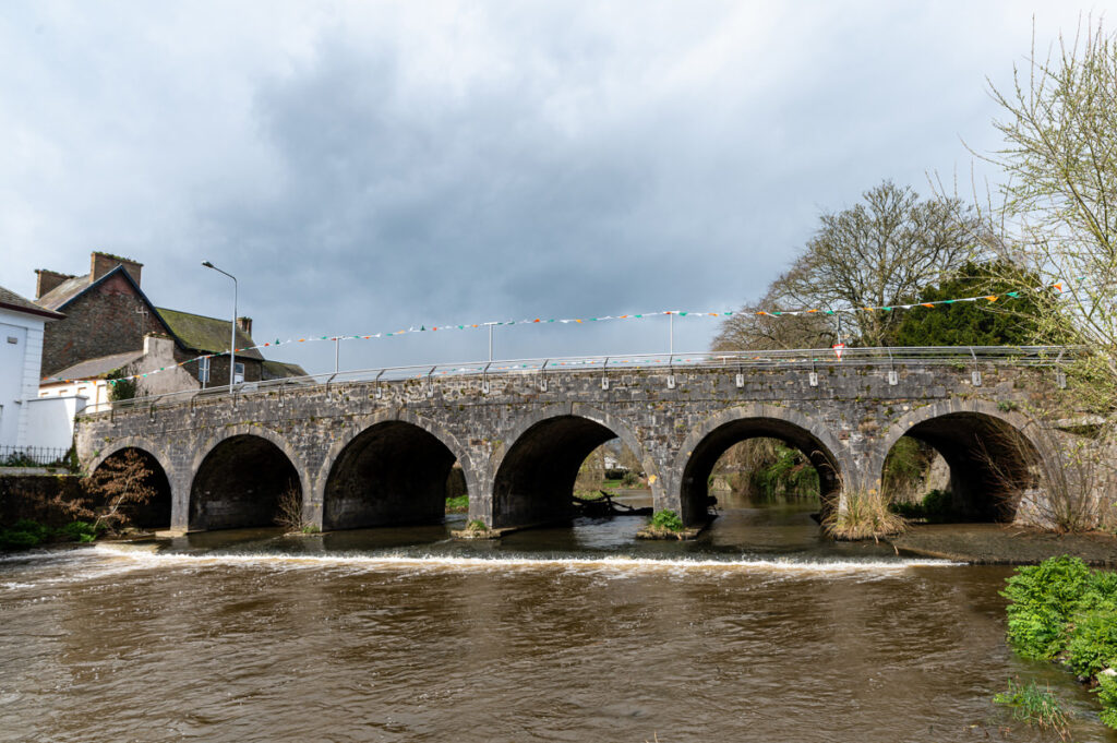
The present bridge over the Dalua dates from 1760, but the site seems to have been an important crossing-point of the river from earliest times. Various phases of bridge construction here, along with the development of the quay walls which regulated the course of the Dalua through Kanturk, must have been influential in the town’s present layout.
This stone bridge, thought to have been the brainchild of the second Earl of Egmont who probably paid for its construction, has drawn comment for a number of features. Its overall aspect is considered attractive and enhanced by minimal pier thickness. It incorporated both a male and female public toilet within its structure, along with a black hole – or ‘strong prison’ – for incarcerating miscreants. Only one of the toilets is now visible, in the eastern arch adjoining O’Brien St.
Another distinctive feature is the six inscribed stones set into the northern parapet, containing poetic lines in eighteenth-century rhyming couplets. These were initially contained in recesses on the northern parapet and were later moved to their present locations.
Inscription on Parapet of Dalua Bridge
I, from my womb on Windmill Hill Great Egmont’s order to fulfil, Was brought with seven of my race His lordship’s honoured town to grace. Secur’d from surly wind and rain The gentle nymph and amorous swain May here their tender vows repeat Which I shall surely ne’re relate. Hence Bluepool’s waving groves delight Amuse the fancy, please the sight, And give such joy as may arise From sylvan scenes and azure skies. See Kanturk Castle and Fermoyle Retreats of Perceval and Boyle. Illustrious in their country’s cause, And guardians of its rights and laws. See Dalua rolls its flood along, And Allua famed in Spenser’s song Where lordly swans in wanton pride, Expand their plumes or stem the tide. The weary here in safe repose Forgetting life’s attendant woes, May sit secure, serene and still And view with joy yon famed hill.
The southern parapet has a plaque which compares the cost of the bridge construction to that of Westminster Bridge in London and Essex Bridge in Dublin, and ends with a quote from Virgil. This plaque was partially concreted over when a new footpath was laid in 2007.
The bridge has seven arches but one is now almost completely enclosed by subsequent developments on Main St. and Strand St.
Historical evidence suggests that, up to the seventeenth century, the course of both rivers was unstable. Flowing through an unconfined marshy area, flooding caused fluctuations in the currents and channels, especially that of the Dalua.
Early documented evidence of a bridge on this site goes back to 1682 when the town of Youghal was charged by the County Grand Jury with carrying out various works including the building, finishing and repairing of bridges. Part of this charge was 3d. (old pence) per plowland for repairing Clanturke (Kanturk) bridge (1). John Percival’s surveyor advised the rebuilding of that bridge in 1704.
In March 1711, the County Grand Jury empowered William Freeman, Kilbarry (bounding Castlecor Demesne), “…to erect a good stone bridge with lime and sand on the River Awndallow where the old wooden bridge stood leading into the town of Kanturk”.
Furthermore, it was required that, “a sufficient key be made above the bridge to prevent the water from changing its course or under-mining the first great arch adjoining to the river of Awnalla ” He was granted £250 to carry out the work and was made responsible for the bridge for seven years . He was later granted £150 more to aid completion (£400 in total).
In May 1713 Percival’s agent, Berkeley Taylor, reported that land erosion over a period of ten years had placed the town in danger of being “carried away” if the course of the river were not reverted to its former direction. In July he declared that the only way to save the town was “by making a good dry stone wall of about 150 yards long” and he intended to begin the work soon.
Again in August, he reported that the men were at work “to fence the bank” following damage to one of the bridge’s pillars as a result of flooding in July.
The building of these quay walls led to the eventual stabilisation of the channels, thus helping to define the town’s layout along the channel. The walls were further developed in a flood-relief programme in the 1980s.